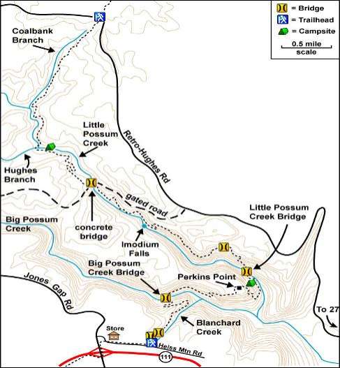
Hike Description Possum Gorge Overview: This section lies between the Soddy Creek Gorge Section and the Rock Creek Gorge Section of the Cumberland Trail. Beginning at its southern terminus off Heiss Mountain Road, the trail descends into the gorge of Big Possum Creek, climbs out of the gorge to the top of Hughes Ridge, and descends into the gorge of Little Possum Creek, then climbs again to the top of the plateau at Retro-Hughes Road between Little Possum and Rock Creek gorges. The trail is 10 miles long with about 1,000 feet of elevation gain and 1,000 feet of elevation loss. Note: Big Possum Bridge and Little Possum Bridge are scheduled for installation in the future. The creeks they will span cannot be crossed during times of high water, but can be safely forded during low stream flow. Trail Guide South to North: Miles.Feature0.0.Heiss Mountain Road From the trailhead, enter forest, then descend past huge boulders to bridge across W Branch Blanchard Creek. The waterfall upstream of the bridge is very photogenic, especially after significant rainfall. Descend gradually, cross logging road, then cross bridge over tributary. Follow creek on side hill past rock houses on left and confluence of E and W branches of Blanchard Creek on right. A spec- tacular waterfall reminiscent of Utah's canyon country lies downstream, very difficult to reach.) Veer left and ascend Bare Point. 1.0.Bare Point From Point, proceed SE through mixed forest. Descend through rhododendron thickets, through rugged old growth hemlock forest, pass interesting 100-foot rock face on right, and descend to the proposed bridge location over Big Possum Creek. The creek can be easily waded except after heavy rains. 1.5.Big Possum Creek Cross Big Possum and ascend steeply to old narrow-gage railroad grade. 1.6.Big Possum Railroad Grade To the left, the railroad grade continues upstream a short distance to the impressive site of the former railroad bridge over Big Possum Creek. The main trail follows railroad grade to the right (downstream) for a short distance. From the grade, turn left and ascend to base of rock escarpment. Proceed downstream, parallel to the escarpment. At an intersection, main trail ascends Hughes Ridge. To right, an old route called "Lain's Lane" passes spectacular rock face containing a large shallow room called "The Amphitheater." Beyond this formation, the lane descends and intersects the railroad grade, but is not a finished trail. (Lain's Lane is named after its re-discoverer, the late Mike Lain of Oak Ridge.) 2.1.Intersection of Main Trail with Lain's Lane From intersection, ascend via two switchbacks to top of Hughes Ridge, then meander through pine forest to east end of Hughes Ridge near Perkins Point. 2.6.East end of Hughes Ridge From end of ridge, descend gradually via curving turns. Pass short side trail on left to overlook of Tennessee River valley with Appalachian mountains beyond. Descend via wooden staircase next to rock face, then via switchbacks--a total of about 400 feet. Trail curves northward around front of Hughes Ridge, then heads NE through a very rocky area above Little Possum Creek. Two small campsites are located to left of trail. 3.3.Little Possum Campsites This is a camping zone and not an official site. Please practice Leave No Trace. From campsites, proceed upstream. Cross steep, rocky side slope, then descend to the proposed bridge location over Little Possum Creek. 3.5.Little Possum Creek Cross Little Possum, ascend about 200 ft, cross an intermittent stream, and reach base of Stack Rock--a tall cylinder-shaped for- mation of layered sandstone. Then climb the Stairway to Heaven to a broad bench. Here a short side trail leads to the top of Stack Rock with views of Hughes Ridge across lower Little Possum Canyon. 3.8.Stack Rock From Stack Rock, ascend gradually via switchbacks and a long side hill cut. After crossing a seasonal stream, ascend a short staircase to a former strip mine bench. This area has recovered somewhat after mining in the 1950s. 4.2.Former strip mine bench On strip mine bench, proceed upstream well above Little Possum Creek with little change in elevation. Below, the creek thunders through The Impassible Canyon with numerous Class IV rapids and one Class V--"Holy Cross". 5.0.North end of strip mine bench From end of bench, descend very gradually to the edge of the canyon, then steeply through Ed's Break, named for its discoverer Ed Sonder of Oak Ridge. Proceed through rhododendron thickets, then down a rock staircase to Imodium Falls--one of the highlights of the Cumberland Trail. Until recently, only a handful of expert kayakers knew of this spectacular C-shaped waterfall. They named it "Imodium" because--upon approaching this po- tentially deadly Class V drop in a small boat--they wished they had taken some of this popular anti-diarrhea drug. A short, steep side trail leads to the base of the falls. To prevent serious injury and erosion of this fragile area, do not attempt any other route to the bottom. 5.6.Imodium Falls From falls, proceed upstream along Little Possum Creek with its numerous Class II-III rapids. When trail ends at creek side, choose between (a) ford creek and rejoin trail on far side, or (b) turn with back toward creek and walk short distance through woods to gravel logging road; turn left onto road and cross creek on concrete bridge. Main trail continues northward on right (N) side of road, a short distance beyond bridge. 6.5.Ford of Little Possum Creek 500 ft below concrete bridge After fording creek, continue through woods to gravel logging road. Turn right onto road and proceed 25 yards toward concrete bridge. Main Trail continues northward on left (N) side of road. 6.6.Trail continuation on N side of gravel road From gravel road, ascend and descend through mixed forest and approach Hughes Branch--a tributary of Little Possum Creek. Ford Little Possum Creek. 7.7.Ford of Little Possum Creek just below Hughes Branch After fording creek, cross ATV lane, ascend through woods, veer left, cross another ATV lane, enter woods and wind around E side of scenic valley. (This valley once contained a settlement called "Old Pennsylvanie" where barrels were made.) Finally, reach top of Coalbank Hill. 8.4.Coalbank Hill Descend from hilltop into middle of grove of giant hemlocks. From here, trail lies within 300-foot-wide corridor: respect adjacent land- owners. Proceed NE along Coalbank Branch, sometimes through open areas that may contain patches of briars. Continue gentle ascent through mixed forest to end of section at (paved) Retro-Hughes Rd. 10.0.Retro-Hughes Road From here it is a 7 mile drive to US-27 in Bakewell. The Cumberland Trail Rock Creek Section begins on NE side of road. To preserve this natural and scenic area, please practice Leave No Trace principles. Directions to Trailheads
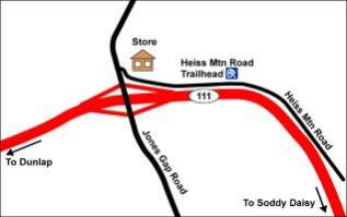
The southern end of this section is accessible from TN-111. From US-27 north of Soddy Daisy, ascend the Cumberland Plateau on TN-111 and precede a total of 5 miles to the Jones Gap Road exit. (Jones Gap Road overpasses TN-111.) Immediately turn right onto (paved) Heiss Mountain Road, a dead-end road that paral-lels TN-111. Precede approximately 0.5 mile from the service station at Jones Gap Road to the end of a guard rail on the left and the nearby trailhead. Plenty of parking is available along the side of the road. The road is sees very little traffic. The paved trailhead parking area is flagged and marked for construction in the future.
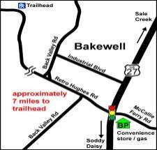
The northern end of this section is accessible from US-27. From Dayton take US-27 13 miles south to Bakewell. At the traffic light, turn right onto Retro-Hughes Road. After a mile, the road veers right and ascends the Cumberland Plateau via a series of sharp curves. Slow, careful driving is recommended. Precede a total of 7 miles from US-27 to the trailhead near a graveled logging company staging area on the right and the nearby trailhead. From here, Retro-Hughes Road heads west and crosses the county line in about one mile. Parking for 5 or 6 cars is available at the edge of the gravel staging area. Be careful not to block logging road
GPS Readings For Important Points: GPS Waypoint in Location WGS 84 format
MUELLER-HINTON AGAR Dieses Medium wird für Sensitivitätstestung auf Antibiotika und für die primäre Isolierung von Neisseria empfohlen. X926 Zusammensetzung in g/l (angenähert): Rinder-Infus .2,0 Maisstärke .1,5 Pepton aus Casein (saures Hydrolysat) . . 17,5 Agar . 17,0 pH . 7,4 ± 0,2 HERSTELLUNG 38,0 g des Mediums werden in einem Liter destillierten Wasser suspendier
VERSIÓN CONSOLIDADA DEL TRATADO DE FUNCIONAMIENTO DE LA UNIÓN EUROPEA ACTOS JURÍDICOS DE LA UNIÓN, PROCEDIMIENTOS DE ADOPCIÓN Y Artículo 288 (antiguo artículo 249 TCE) Para ejercer las competencias de la Unión, las instituciones adoptarán reglamentos, directivas, decisiones, recomendaciones y dictámenes. El reglamento tendrá un alcance general. Será obligatorio en todos sus e
 Directions to Trailheads